EnterVol for ArcGIS 1.8

It is designed to perform volumetric analysis within ArcGIS Desktop
Rating
Your vote:
Latest version:
1.8.3 See all
Developer:
Screenshots
1 / 2
Download

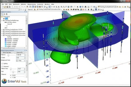
EnterVol for ArcGIS is a program designed to perform volumetric analysis within ArcGIS Desktop. EnterVol was architected from its inception to offer an easy transition for ESRI users from surface based modeling into the true 3D world of volumetric modeling.

Comments

User

Your vote:

Related software

ArcGIS Explorer
ArcGIS Explorer
Free
rating

ArcGIS Explorer Desktop is a GIS viewer that gives you an easy way to explore.

ArcGIS Military Analyst
Free
rating

ArcGIS extension with geospatial analysis capabilities for mlitary applications.

ArcGIS Image Server AutoCad Client
ArcGIS Image Server AutoCad
Free
rating

You can view an image service using various client applications.

Genesis IV
Genesis IV
Free
rating

A landscape product designed specifically to help teach geographical concepts.

ArcGIS for AutoCAD 300
Free
rating

It is a plug-in that provides interoperability between AutoCAD and ArcGIS.

Tags

3D modeling ArcGIS modeling Volumetric modeling Volumetric analysis Visualization ArcGIS